"Three hundred men and their instruments entered the Charnel Lands on the morning of the 14th of Martius, A.S. 73. The Bureau of Records commissioned them to draw a map. The Charnel Lands drew something on them instead." — Bureau of Doctrine, Debrief Summary 73-C (Sealed)
#On the Commission
The Synod had held the Sagittal Line for eight years. Eight years of trenches, bells, wire, and the carefully maintained fiction that the territory east of the wire was merely "contested" rather than irrecoverably consumed. The fiction required a map. Maps are the grammar of sovereignty; a state that cannot chart its borders cannot, in the strictest doctrinal sense, claim to have any, and the Bureau of Records — whose entire institutional theology rests upon the premise that what is written is what is real — found this intolerable.
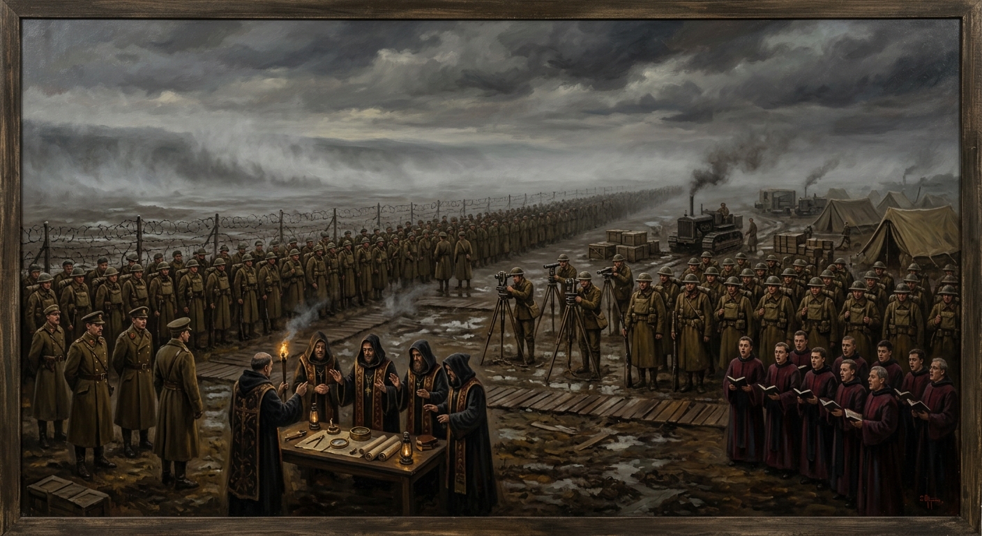
The commission was issued on the 2nd of Februarius, A.S. 73, under the joint seal of the Bureau of Records and the Bureau of Engineering, with a countersignature from the Bureau of War that arrived six days late and bore a coffee stain the Bureau of Records has classified as "deliberate editorial commentary." The writ authorized a survey expedition of three hundred souls — cartographers, trigonometric surveyors, chain-men, a sixteen-voice hymn-choir for spiritual protection, a full Bureau of Doctrine theological escort of nine presbyters, four Bureau of Engineering geologists, two Bureau of Purity observers whose role was never specified in any document the author has been permitted to read, and two hundred and eighteen soldiers of the Line whose primary qualification was that they were considered expendable by their commanding officers and whose secondary qualification was that they could march in a straight line, a skill the Charnel Lands would shortly render irrelevant.
The expedition's stated objective, per Bureau of Records Commission 73-C, was to "produce a comprehensive sacral geography of the territories between the Sagittal Line and the eastern limit of previously documented habitation, with particular attention to topographic features of military significance, relic-site locations, and the present disposition of civilian populations." The phrase "comprehensive sacral geography" deserves a moment's admiration. It is the Bureau's way of saying "draw a map of Hell" without admitting that Hell is what requires mapping. The word cartography was avoided — "cartography implies heathen empiricism," as the Bureau's own Stamped Erratum from that year's Harmonization reminds us. What they wanted was a map. What they commissioned was a theology.
The expedition leader was Colonel-Cartographer Oswin Reath (Unregistered), a man whose Bureau of Records dossier runs to forty-seven pages and whose Bureau of War dossier runs to three — a ratio that tells you everything about the kind of soldier the Bureau of Records prefers to command its adventures. Reath had surveyed the Rhine corridor, the Carpathian passes, and the supply routes between Bastion-Przemyśl and the rail depots of the Heartlands. He was meticulous, humorless, and entirely devoid of the kind of imagination that might have saved him. He drew straight lines. He believed in straight lines. The Charnel Lands, which believe in nothing and in which nothing is straight, would find this quality educational.
#On the Departure
They mustered at Forward Staging Point Kessler (Unregistered), a trench-depot three miles behind the wire south of Bastion-Irongate, on the morning of the 14th of Martius. The day was cold, clear, and — according to the meteorological log kept by the Bureau of Engineering's weather clerk — "unremarkable in all respects save that the barometric readings appeared to be climbing without cause." The hymn-choir sang the Canticle of Assured Return (Unregistered). The Bureau of Doctrine's nine presbyters blessed the instruments — every compass, every chain, every brass protractor, every folio of blank mapping paper. The blessing took four hours. The instruments, which had no opinions on the matter, accepted it.
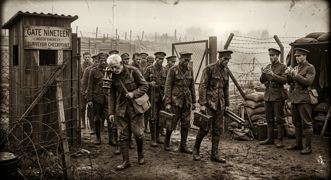
They crossed the wire at Gate Nineteen (Unregistered), Irongate Southern Sector, at the sixth bell. The trench sentries logged three hundred souls passing the fire-step in columns of two. The sentries at the second wire logged two hundred and ninety-eight. The sentries at the third wire — the last Synod position before the desolation begins — logged two hundred and ninety-six. Four men lost between the first wire and the third, a distance of six hundred yards, in broad daylight, on a road the Bureau of War has patrolled daily since A.S. 67. The Bureau's investigation into the discrepancy lasted three hours and concluded that the original count had been "transcribed in error." The investigation's findings were filed before the expedition had been gone a full day.
They carried supplies for thirty days. They carried six reliquaries — two from the Ossuary Rings of Bastion-Constantinople, two from the Cathedral Stores at Strasbourg, and two whose provenance the Bureau of Relics has declined to confirm or deny, a refusal that costs the Bureau four stamps and a countersignature every time it is exercised. They carried three hundred folios of blank mapping paper, two tons of trigonometric chain, a portable printing press for field notation, and — per the theological escort's packing manifest — forty-seven candles of consecrated tallow, each one blessed by a different parish priest. The manifest does not explain why forty-seven. The number of parishes in the Strasbourg metropolitan see is forty-six.
#On What Was Found
The expedition entered the Charnel Lands — the fallen territories east of the Line, the domain of the Great Deceiver and his seven squabbling generals — on the afternoon of the 14th of Martius, A.S. 73.
What they found is, in the strictest and most frustrating archival sense, classified. Commission 73-C's products were destroyed. The debriefings were sealed. The surviving personnel were reassigned under oath of silence, and the oath — filed with the Bureau of Oaths, notarized by the Bureau of Records, and countersigned by the Bureau of Purity — carries a penalty clause that involves the removal of the tongue, the filing of the tongue in the Bureau's Dead Letter vault, and the reassignment of the tongue-holder to "a position commensurate with their reduced communicative capacity." The Bureau of Purity drafted that clause. One recognises the hand.
What is known — from the fragments that survived the burning, from the Bureau of Doctrine's own debrief summary, from the Bureau of Engineering's geological assessment (which, being filed in a sub-registry that the Bureau of Records apparently forgot it owned, escaped the initial purge), and from the personal effects returned to fourteen families across Europe — is the following.
The expedition marched east for nine days. On each of the nine days, Colonel-Cartographer Reath ordered his surveyors to take readings and produce preliminary charts. On each of the nine days, the charts disagreed with the previous day's charts. The disagreement was total. Distances measured one day would halve the next and triple the day after. Compass bearings taken at the same point by three different surveyors produced three different norths. A ridge that appeared on the morning's sketch would be absent by afternoon and replaced by a marsh that the afternoon sketch placed seven miles east of its morning position. The sun, where visible, moved at velocities the Bureau of Engineering's astronomical tables could not reconcile. The stars, where visible, were wrong.
On the eleventh day the expedition encountered the first bodies — their own forward scouts, posted two days prior, dead in a circle with their instruments smashed and their mapping folios open on the ground. The folios contained drawings. The drawings were of faces. The scouts' commanding officer, Sergeant Kael Murt (Unregistered), was found seated upright against a cairn that had not existed when the scouts departed, his compass in his hand, its needle spinning. His field diary — a personal item, not Bureau property, and therefore missed during the subsequent purge — contained entries through the morning of the ninth day. The entries are lucid, competent, and increasingly brief. The final entry reads: "The geography is correct. We are the error."
On the fourteenth day — or what the survivors believed to be the fourteenth day; all clocks had stopped by the twelfth — the expedition was attacked. By what, the debrief summary does not specify. The Bureau of Doctrine's sealed assessment calls it "a hostile engagement with forces of unclassified sin-general affiliation." The Bureau of Engineering's geological assessment, written in a drier register that makes it paradoxically more informative, notes "a meteorological event of thirty-six hours' duration during which the ambient temperature exceeded measured capacity of available thermometric instruments and the terrain exhibited locomotive properties inconsistent with geological precedent." In plain language: the ground moved, the air burned, and something came out of the fog that the Bureau has spent twenty-eight years declining to name.
Two hundred and twelve men died on the fourteenth day. The remainder broke. Colonel-Cartographer Reath attempted to rally them. His last recorded order, transcribed from the field log of Surveyor First-Class Edda Grieve (Unregistered), was: "Hold the chains. The chains are the truth." He was not seen again. The Bureau of Records lists him as "Missing, Presumed Cartographic."
Earlier Bureau summaries listed casualties of the fourteenth day as "one hundred and seventy-three." This figure has been corrected. The original count excluded the theological escort, the Bureau of Purity observers, and the four additional names on the muster roll. The corrected figure is two hundred and twelve, or two hundred and sixteen if one includes the four whose presence was never formally acknowledged.
The Bureau acknowledges the corrected figure of two hundred and twelve and notes that any discrepancy with earlier publications reflects "enhanced archival methodology," not error.
#On the Fourteen
Fourteen men returned.
They staggered through Gate Nineteen on the 2nd of Aprilis — nineteen days after departure, five days after the last supplies should have been exhausted, and four days after the Bureau of War had closed the file and logged the expedition as "Overdue, Presumed Lost, Administratively." The gate sentries logged fourteen souls. The count was verified by three separate tallies. All fourteen carried their instruments. All fourteen carried their mapping folios. All fourteen were in the uniforms they had departed in, though the uniforms were aged — thread-worn, sun-faded, chemically discoloured in patterns the Bureau of Engineering could not explain.
Their identities were confirmed by wax-seal, hymn-memory, and bone-density comparison. They were themselves. They had aged, but not by the nineteen days they had been absent — they had aged by what the Bureau of Medicine estimated, conservatively, at "a period consistent with three to seven additional years of physiological wear." One surveyor's hair had gone white. Two had developed cataracts. A chain-man named Pieter Dahlgren (Unregistered) had lost all his teeth and could provide no account of when or how. All were lucid. All could speak. All refused to speak voluntarily, and the debriefings — conducted over the following week by a joint panel of the Bureau of Doctrine, Bureau of Records, and Bureau of Purity — required the formal invocation of the Oath of Compelled Testimony (Unregistered) to produce any usable material.
The debriefings produced contradictory accounts. The fourteen agreed on almost nothing. Where they had walked, what they had seen, how long they had marched, where the sun had been, what the terrain looked like — all contradicted, all irreconcilable, all delivered with the calm conviction of men who were certain of what they had witnessed and equally certain that what the man beside them had witnessed was wrong.
On one point they agreed.
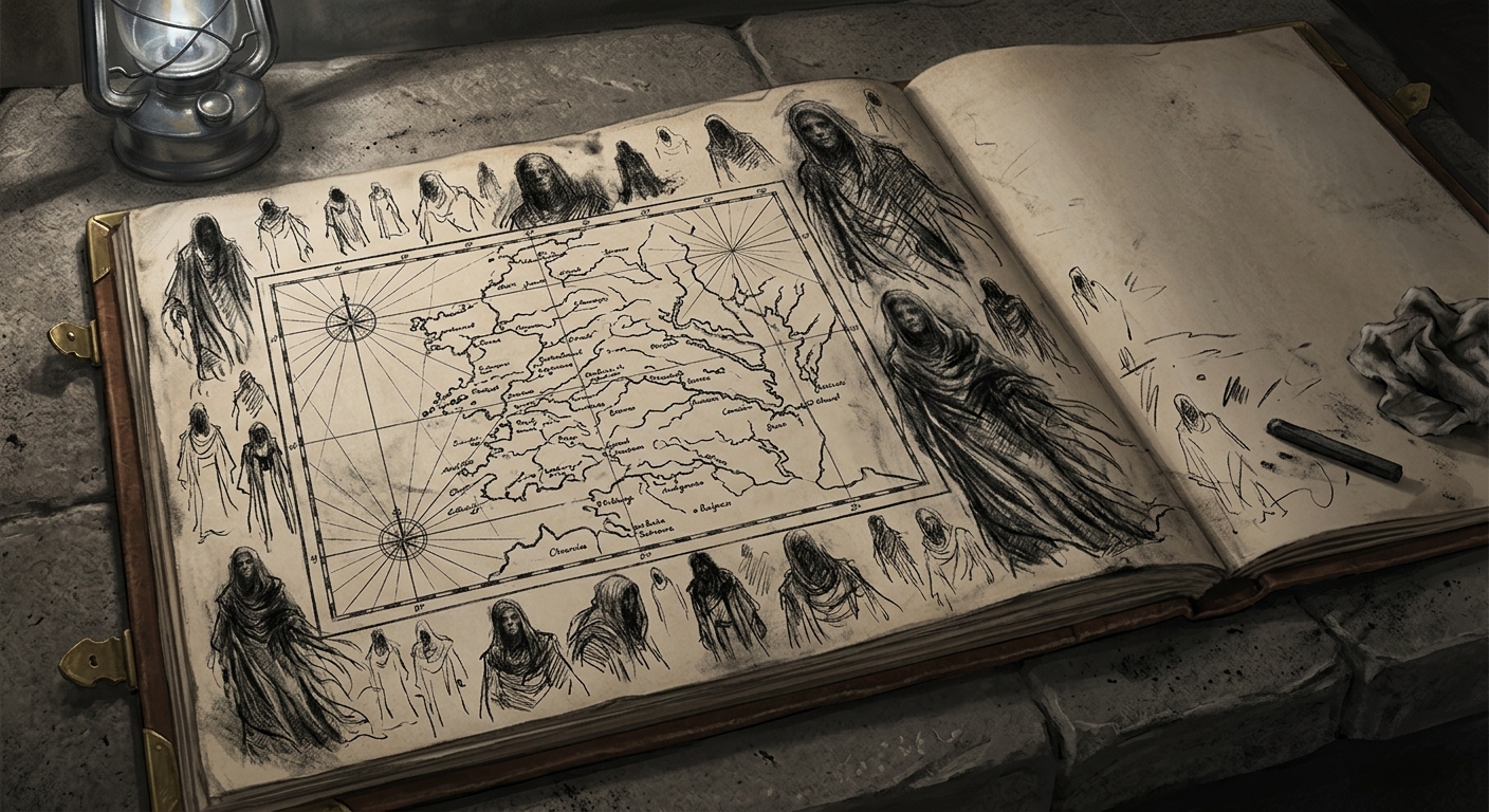
Every one of the fourteen — cartographers, surveyors, chain-men, the two surviving soldiers of the theological escort's guard detail — had, at some point during the expedition, drawn a face in the margins of their mapping folio. The face was the same face. It was rendered in charcoal, in ink, in graphite, in one case in what the Bureau of Rites later determined to be the surveyor's own blood. The renderings varied in skill — some were crude, the work of men who could draw topographic contours but had never attempted a portrait; others were accomplished, with shading and dimension that spoke of hours of careful work. All fourteen faces were recognisably the same: vast, spectral, robed, patient, the features blurred as if seen through fog, the expression one of absolute and impenetrable indifference.
None of the fourteen remembered drawing it.
The charcoal sketches from the Iron Wastes — Maldrake's territory — were a separate matter. These were not of the face. These were topographic renderings, landscapes of slag and fire, and they arrived at the Bureau of Rites' assessment desk still warm to the touch. The Bureau of Rites classified the warmth as "residual kinetic sympathy" and locked the sketches in an asbestos-lined vault in the sub-basements of the Basilica of the Ledgered Saints. I have held them in my own hands. The classification is generous. What the page transmits is heat — the kind that comes from standing too close to something still burning, though the thing it depicts has been drawn for one hundred and twenty-eight years and the fires it shows have been burning for a hundred and fifty-five.
#On the Burning
The maps were burned on the 9th of Aprilis, A.S. 73. Seven days after the survivors' return. One day after the debriefings concluded.
The order came from the Bureau of Doctrine, countersigned by the Bureau of Records — a collaboration of unusual speed that suggests the order was drafted before the debriefings began. The burning was conducted in the courtyard of Bastion-Irongate's Chapel of the Seventh Stair, witnessed by a Procurator of the Bureau of Purity, a Seal-Clerk of the Bureau of Records, and a Cantor who sang the Rite of Profitable Forgetting (Unregistered) throughout. Three hundred folios, fourteen charcoal studies, six provisional topographic sheets, and Reath's personal compass (which, the Bureau of Engineering noted, still pointed in a direction that does not correspond to any cardinal bearing on the standard rose) — all fed to consecrated flame.
The fourteen folios containing the face were burned last. The Cantor reported — in a supplementary filing the Bureau of Doctrine later reclassified from "Observational" to "Non-Material" — that the face on each folio remained visible longer than the paper on which it was drawn. The charcoal outlines persisted in the flame for "a duration consistent with nine heartbeats," and during those nine heartbeats the fourteen faces — each one held by a different clamp, each one curling in a different part of the fire — appeared to turn toward one another, as if the drawings were conferring.
The Cantor's supplementary filing was sealed within the hour. The Cantor was reassigned. I will not speculate on where. The Bureau of Bells accepted him, which, given what the Bureau of Bells accepts, may or may not have been a mercy.
#On the Reassignment
The fourteen survivors were reassigned to the Bureau of Bells.
This requires explanation, because the Bureau of Bells is not — despite what its detractors in the Bureau of War maintain — a penal posting. It is an administrative body of considerable sophistication, responsible for the doctrinal acoustics of an entire continent, and its members are, by and large, competent professionals whose only deficiency is that they spend so much time listening to bells that they have forgotten how to listen to anything else.
The fourteen were not assigned to bell-ringing. They were assigned to bell-mapping — the maintenance of the Synod's acoustic charts, which track every peal-schedule, counter-toll protocol, and bellway corridor from the Baltic to the Aegean. The Bureau of Bells considered this an excellent use of their cartographic training. The fourteen, who had entered Hell with protractors and returned with a stranger's face etched into their unconscious, considered it — one assumes — preferable to the alternative.
Seven of the fourteen are still alive as of A.S. 201. All seven remain in the Bureau of Bells. None have spoken publicly about the expedition. None have requested transfer. None have drawn anything freehand since their return. Surveyor First-Class Edda Grieve, the most senior surviving member, is now seventy-three and oversees the acoustic charts for the Rhineland sector from an office in Cologne. Her office contains no mirrors, no charcoal, and no blank paper that is not pre-printed with bell-schedule grids. Her colleagues consider this a harmless eccentricity. I consider it the most rational behaviour in the building.
#On What Was Learned
The Bureau of Records commissioned the expedition to draw a map. The expedition returned with fourteen contradictory maps that agreed on nothing except a face. The maps were burned. The face persisted. The Bureau of Records filed Commission 73-C under "Completed — No Usable Product" and moved on to the next filing number.
I will now tell you what was learned, because the Bureau will not.
The Charnel Lands cannot be mapped. The territory east of the Sagittal Line does not submit to measurement. Distances change. Bearings shift. Landmarks relocate themselves between surveys with the casual insolence of a Bureau clerk rearranging his desk. The seven Sin-Generals occupy territory and are territory; their domains are extensions of their nature, and their nature is, by the Creator's own unexplained design, fundamentally hostile to the kind of fixed geometric truth that a map requires. Maldrake's Iron Wastes shift with his furnaces. Syrion's Vales drift with his fog. Morwen's Hollow Vale copies the terrain of wherever you came from until you can no longer distinguish the copy from the original. Velmora's Gilded Chasm contracts around its visitors like a closing fist. The ground lies. The sky collaborates.
Three hundred men marched into the Charnel Lands to draw a line around the enemy's holdings. The enemy does not have holdings. The enemy is the holdings. The distinction cost two hundred and eighty-six lives, fourteen shattered minds, three hundred folios of useless paper, and one Colonel-Cartographer whose epitaph — "Missing, Presumed Cartographic" — is the single most honest thing the Bureau of Records has ever filed.
The Synod has not commissioned a general cartographic survey of the Charnel Lands since. Individual Bureau operations — the Bureau of Shadows' incursions, the Bureau of War's forward patrols, the Bureau of Engineering's soil-resonance surveys — produce fragmentary intelligence that is immediately classified and filed in sub-registries that do not communicate with one another. The Bureau of Records maintains, in its official position, that the territories east of the Line are "pending comprehensive survey." The survey has been pending for one hundred and twenty-eight years. The Bureau does not consider this a delay. The Bureau considers this prudence.
And the face remains.
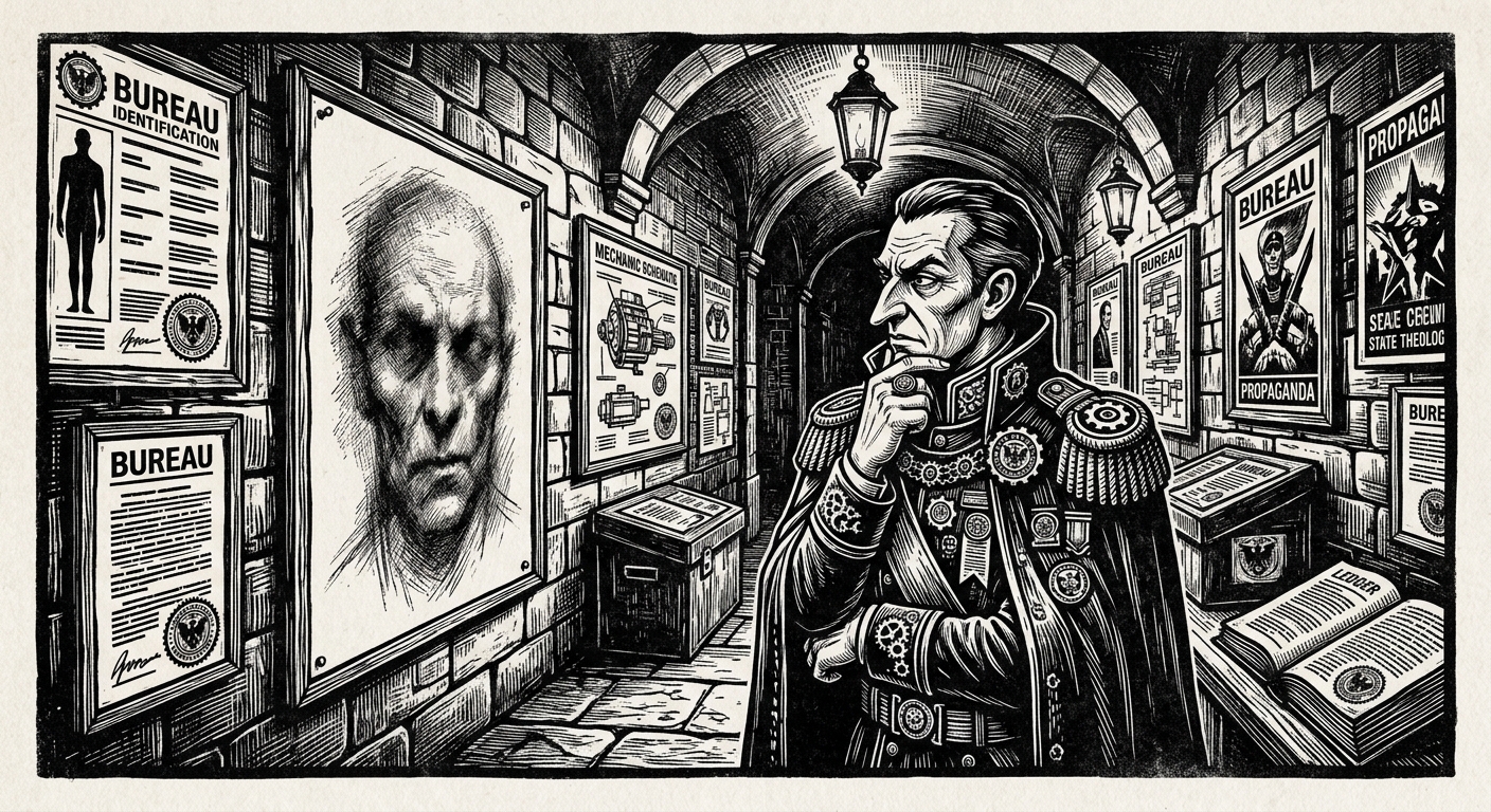
Syrion, the Languid Dreamer, the Fourth-Manifested, He Who Drifted In During the Exhaustion — the composite reconstruction assembled from the testimony of fourteen survivors hangs in the Bureau of Doctrine's sealed gallery in Strasbourg. It is the only confirmed likeness of a Sin-General produced from first-hand observation under controlled Bureau conditions. The Bureau uses it for identification training. The fourteen survivors were never told that what they drew had a name. They were never told that their involuntary portraits constituted the Synod's single most valuable piece of intelligence about the enemy's physiognomy. They were told nothing. They were reassigned to the Bureau of Bells, where they ring things that cannot answer back, and where the only maps they draw are maps of sound — sound being, unlike geography, a phenomenon that does not lie about where it has been.
The expedition drew a map of the Charnel Lands. The Charnel Lands drew a face on the expedition. I leave it to the reader — assuming the reader has the doctrinal clearance to have reached this sentence, and if not, the reader should be aware that the Bureau of Purity has been notified — to determine which product was more truthful.